IGSN Descriptive Metadata
The ARDC IGSN service requires users to provide metadata describing their sample when minting an IGSN. This metadata facilitates discovery through central catalogues and ensures end-users can resolve IGSNs to a meaningful description.
The service currently supports the following descriptive metadata schemas for use with geophysical samples such as rock, soil and sediment.
Both schemas contain a required set of elements and attributes that ensure the minimum metadata for discovery and evaluation are available for all IGSNs. More information about these schemas can be found in the sections below.
Users of the IGSN Service Web Interface generally do not need to have an understanding of the schema as the interface guides the metadata entry. However, users of the ARDC IGSN API should take some time to review the schemas as they will need to pass valid XML in their mint and update requests.
While the ARDC IGSN service currently only supports descriptive metadata for earth science samples, the service has been designed and developed in a way which allows it to be easily extended to other disciplines and metadata schemas.
ARDC is interested in working with other communities in order to extend the service for use with other physical sample types e.g. water, vegetation, archaeological and biological specimens. If you are interested in participating in this process please contact services@ardc.edu.au to discuss your requirements.
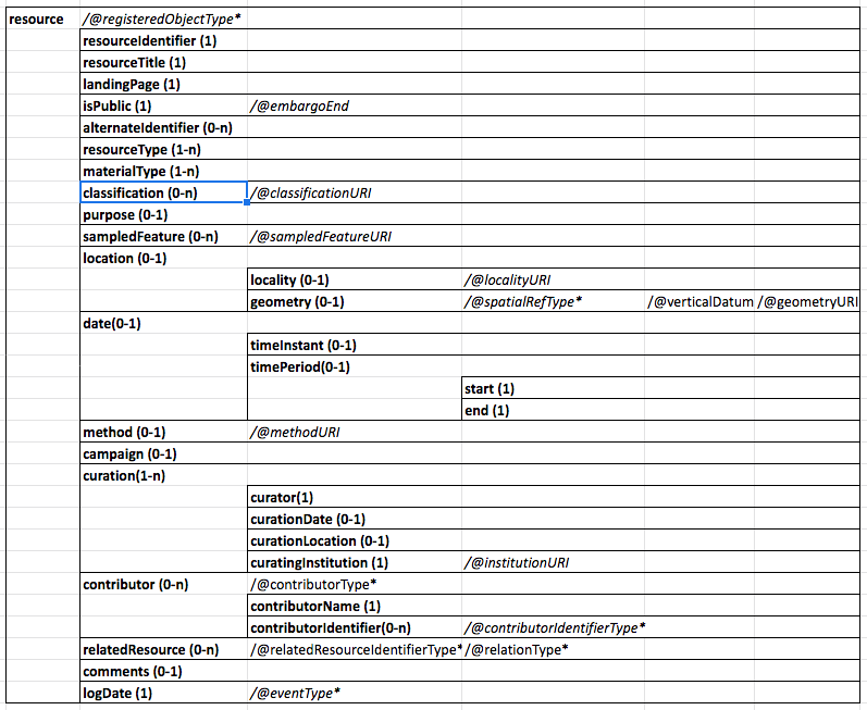
CSIRO IGSN Schema version 3.0
Originally developed by CSIRO for their internal geosample requirements. The schema is loosely based on early drafts of the IGSN Descriptive Metadata Schema.
The CSIRO schema has been superseded by the ARDC IGSN Descriptive Schema but will continue to be supported to ensure users can continue to mint and update their IGSNs with existing integrations.
When minting IGSNs with the CSIRO IGSN Schema via the API, the ARDC IGSN service will automatically generate and store a "current" ARDC IGSN Descriptive Schema version for the IGSN. This is to ensure users can edit their IGSNs via the web interface.
Schema documentation: https://igsn.csiro.au/schemas/3.0/doc/

Metadata Example

<?xml version="1.0" encoding="UTF-8" standalone="yes"?>
<resources xmlns="https://igsn.csiro.au/schemas/3.0" xmlns:xsi="http://www.w3.org/2001/XMLSchema-instance" xsi:schemaLocation="https://igsn.csiro.au/schemas/3.0 https://igsn.csiro.au/schemas/3.0/igsn-csiro-v3.0.xsd">
    <resource registeredObjectType="http://pid.geoscience.gov.au/def/voc/igsn-codelists/PhysicalSample">
        <resourceIdentifier>CSTSTDOCO1</resourceIdentifier>
        <landingPage>http://example.com.au/abcde</landingPage>
        <isPublic>true</isPublic>
        <resourceTitle>A title worthy for kings</resourceTitle>
        <alternateIdentifiers>
            <alternateIdentifier>Another identifer option</alternateIdentifier>
            <alternateIdentifier>And again another identifer</alternateIdentifier>
        </alternateIdentifiers>
        <resourceTypes>
            <resourceType>http://vocabulary.odm2.org/specimentype/core</resourceType>
            <resourceType>http://vocabulary.odm2.org/specimentype/corePiece</resourceType>
        </resourceTypes>
        <materialTypes>
            <materialType>http://vocabulary.odm2.org/medium/particulate</materialType>
            <materialType>http://vocabulary.odm2.org/medium/air</materialType>
        </materialTypes>
        <classifications>
            <classification classificationURI="http://www.classification.com/tin">Some phrases for classification</classification>
            <classification classificationURI="http://www.classification.com/gold">maybe gold or silver</classification>
        </classifications>
        <purpose>This is a test resource for demo multi</purpose>
        <sampledFeatures>
            <sampledFeature sampledFeatureURI="http://www.samplefeature.com/uri/abcde">A sample feature sitting somewhere</sampledFeature>
            <sampledFeature sampledFeatureURI="http://www.samplefeature.com/uri/hfsgfs">A lalala land</sampledFeature>
            <sampledFeature sampledFeatureURI="http://www.samplefeature.com/uri/gfnbgdgfd">Curry for dinner</sampledFeature>
        </sampledFeatures>
        <location>
            <locality localityURI="http://google.map/perth">Canning vale</locality>
            <geometry srid="https://epsg.io/4326" verticalDatum="https://epsg.io/4326" geometryURI="http://www.altova.com">POLYGON ((127.05688476563 -20.5224609375, 124.24438476563 -28.2568359375, 143.22875976563 -32.1240234375, 142.17407226563 -20.8740234375, 127.05688476563 -20.5224609375))</geometry>
        </location>
        <date>
            <timePeriod>
                <start>2003</start>
                <end>2002</end>
            </timePeriod>
        </date>
        <method methodURI="http://method.com/collection">Lab sampling</method>
        <campaign>a</campaign>
        <curationDetails>
            <curation>
                <curator>Curtin</curator>
                <curationDate>2001-12</curationDate>
                <curationLocation>Bentley</curationLocation>
                <curatingInstitution institutionURI="http://www.curtin.org">Curtin University</curatingInstitution>
            </curation>
            <curation>
                <curator>CSIRO</curator>
                <curationDate>2001-12</curationDate>
                <curationLocation>In the lab somewhere</curationLocation>
                <curatingInstitution institutionURI="http://csiro.au">ARRC</curatingInstitution>
            </curation>
        </curationDetails>
        <contributors>
            <contributor contributorType="http://registry.it.csiro.au/def/isotc211/CI_RoleCode/pointOfContact">
                <contributorName>Victor Tey</contributorName>
                <contributorIdentifier contributorIdentifierType="http://pid.geoscience.gov.au/def/voc/igsn-codelists/ORCID">Contributor to something</contributorIdentifier>
            </contributor>
            <contributor contributorType="http://registry.it.csiro.au/def/isotc211/CI_RoleCode/originator">
                <contributorName>Adam Brown</contributorName>
                <contributorIdentifier contributorIdentifierType="http://pid.geoscience.gov.au/def/voc/igsn-codelists/EISSN">this has to mean something</contributorIdentifier>
            </contributor>
        </contributors>
        <relatedResources>
            <relatedResource relatedResourceIdentifierType="http://pid.geoscience.gov.au/def/voc/igsn-codelists/ARK" relationType="http://pid.geoscience.gov.au/def/voc/igsn-codelists/HasDigitalRepresentation">A related resource somewhere</relatedResource>
            <relatedResource relatedResourceIdentifierType="http://pid.geoscience.gov.au/def/voc/igsn-codelists/DOI" relationType="http://pid.geoscience.gov.au/def/voc/igsn-codelists/IsMemberOf">A related resource somewhere</relatedResource>
        </relatedResources>
        <comments>This is a comment fit for kings</comments>
        <logDate eventType="registered">2002</logDate>
    </resource>
</resources>
Note: All geometry needs to be specified in the metadata as Well Known Text (WKT). Wikipedia has some good examples https://en.wikipedia.org/wiki/Well-known_text_representation_of_geometry
The schema supports the following spatial referencing system identifier (SRID) attribute values.
https://epsg.io/4326
https://epsg.io/3112
https://epsg.io/4939
https://epsg.io/4283
https://epsg.io/5711
https://epsg.io/5712
https://epsg.io/8311
https://epsg.io/5714
https://epsg.io/5715
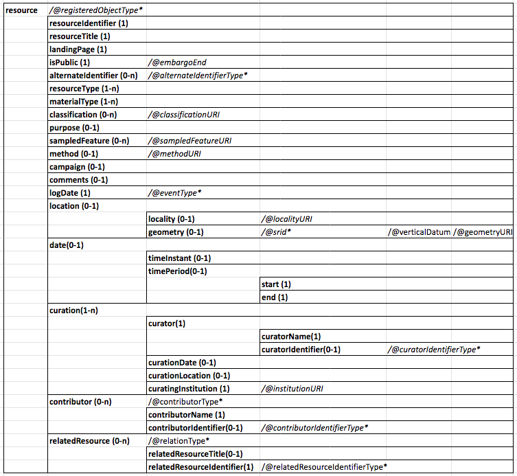
ARDC IGSN Descriptive Schema 1.0
The ARDC IGSN Descriptive Schema is a slightly modified version of the CSIRO IGSN Schema that provides extra elements and attributes for capturing rich relationship information. The ARDC schema is currently the only schema supported by the IGSN editor and is the default schema used throughout the service.
Schema location: https://identifiers.ardc.edu.au/igsn-schema/descriptive/1.0/resource.xsd
The ARDC IGSN Descriptive Schema requires that the IGSN value in the resourceIdentifier element is the handle prefix.+ the IGSN value. This ensures the system can identify the difference between test and production IGSNs.
The handle prefix for production IGSNs is "10273/" and the test prefix is "20.500.11812/".
E.g. <resourceIdentifier>20.500.11812/XXZT2CSTSTDOCO2A</resourceIdentifier>

Metadata Example
<?xml version="1.0" encoding="UTF-8"?>
<resources xmlns="https://identifiers.ardc.edu.au/schemas/ardc-igsn-desc" xmlns:xsi="http://www.w3.org/2001/XMLSchema-instance" xsi:schemaLocation="https://identifiers.ardc.edu.au/schemas/ardc-igsn-desc https://identifiers.ardc.edu.au/igsn-schema/descriptive/1.0/resource.xsd">
    <resource registeredObjectType="http://pid.geoscience.gov.au/def/voc/ga/igsncode/PhysicalSample">
        <resourceIdentifier>20.500.11812/XXZT1TESTJA3</resourceIdentifier>
        <landingPage>https://exampleLandingPageURL/view/20.500.11812/XXZT1TESTJA3</landingPage>
        <isPublic>true</isPublic>
        <resourceTitle>Example sample title</resourceTitle>
        <resourceTypes>
            <resourceType>http://vocabulary.odm2.org/specimentype/core</resourceType>
            <resourceType>http://vocabulary.odm2.org/specimentype/coreHalfRound</resourceType>
        </resourceTypes>
        <materialTypes>
            <materialType>http://vocabulary.odm2.org/medium/mineral</materialType>
        </materialTypes>
        <classifications>
            <classification classificationURI="https://en.wikipedia.org/wiki/Granite">Granite</classification>
            <classification classificationURI="https://en.wikipedia.org/wiki/Diorite">Diorite</classification>
        </classifications>
        <purpose>Purpose</purpose>
        <sampledFeatures>
            <sampledFeature sampledFeatureURI="SampledFeatureURL">Example sampled feature</sampledFeature>
        </sampledFeatures>
        <date>
            <timeInstant> 2020-07-30 </timeInstant>
        </date>
        <location>
            <locality localityURI="http://locality.url">Western Australia</locality>
            <geometry geometryURI="https://Geo.url" srid="https://epsg.io/4326" verticalDatum="https://epsg.io/4326">POLYGON ((10.689 -25.092, 34.595 -20.17, 38.814 -35.639, 13.502 -39.155, 10.689 -25.092))</geometry>
        </location>
        <method methodURI="http://ExampleMethod.url">Block sampling</method>
        <campaign>Project West A - 2144</campaign>
        <curationDetails>
            <curation>
                <curator>
                    <curatorName>John Smith</curatorName>
                    <curatorIdentifier curatorIdentifierType="http://pid.geoscience.gov.au/def/voc/ga/igsncode/DOI">10.523546</curatorIdentifier>
                </curator>
                <curationDate>2020-08-05</curationDate>
                <curationLocation>Curation Location</curationLocation>
                <curatingInstitution institutionURI="https://exampleInstitution.url">Research Lab 123</curatingInstitution>
            </curation>
            <curation>
                <curator>
                    <curatorName>Prof. R Jay</curatorName>
                    <curatorIdentifier curatorIdentifierType="http://pid.geoscience.gov.au/def/voc/ga/igsncode/DOI">10.523546</curatorIdentifier>
                </curator>
                <curationDate>2020-08-05</curationDate>
                <curationLocation>Second Curation Location</curationLocation>
                <curatingInstitution>Research Lab 2004</curatingInstitution>
            </curation>
        </curationDetails>
        <contributors>
            <contributor contributorType="http://registry.it.csiro.au/def/isotc211/CI_RoleCode/pointOfContact">
                <contributorName>Sarah Contributor</contributorName>
                <contributorIdentifier contributorIdentifierType="http://pid.geoscience.gov.au/def/voc/ga/igsncode/ORCID">0000-1111-2222-9999</contributorIdentifier>
            </contributor>
            <contributor contributorType="http://registry.it.csiro.au/def/isotc211/CI_RoleCode/collaborator">
                <contributorName>Greg Chalms</contributorName>
                <contributorIdentifier contributorIdentifierType="http://pid.geoscience.gov.au/def/voc/ga/igsncode/ORCID">0000-1111-2222-9998</contributorIdentifier>
            </contributor>
        </contributors>
        <relatedResources>
            <relatedResource relationType="http://pid.geoscience.gov.au/def/voc/ga/igsncode/HasReferenceResource">
                <relatedResourceTitle>Example Publication Title</relatedResourceTitle>
                <relatedResourceIdentifier relatedResourceIdentifierType="http://pid.geoscience.gov.au/def/voc/ga/igsncode/EISSN">eissn-188-7</relatedResourceIdentifier>
            </relatedResource>
            <relatedResource relationType="http://pid.geoscience.gov.au/def/voc/ga/igsncode/IsDocumentedBy">
                <relatedResourceIdentifier relatedResourceIdentifierType="http://pid.geoscience.gov.au/def/voc/ga/igsncode/PURL">http://purl.org/resource101</relatedResourceIdentifier>
            </relatedResource>
            <relatedResource relationType="http://pid.geoscience.gov.au/def/voc/ga/igsncode/IsDerivedFrom">
                <relatedResourceTitle>Example Sample 1</relatedResourceTitle>
                <relatedResourceIdentifier relatedResourceIdentifierType="http://pid.geoscience.gov.au/def/voc/ga/igsncode/IGSN">20.500.11812/XXZT1TEUSTJA5</relatedResourceIdentifier>
            </relatedResource>
        </relatedResources>
        <comments>Relevant comments to the sample and the sampling technique</comments>
        <logDate eventType="updated">2020-11-24T04:36:29.300Z</logDate>
    </resource>
</resources>
Note: All geometry needs to be specified in the metadata as Well Known Text (WKT). Wikipedia has some good examples https://en.wikipedia.org/wiki/Well-known_text_representation_of_geometry
The schema supports the following spatial referencing system identifier (SRID) attribute values.
https://epsg.io/4326
https://epsg.io/3112
https://epsg.io/4939
https://epsg.io/4283
https://epsg.io/5711
https://epsg.io/5712
https://epsg.io/8311
https://epsg.io/5714
https://epsg.io/5715
